Fog, a natural phenomenon that transforms landscapes into ethereal realms, is highly coveted by photographers for its ability to create a dreamy, almost mystical atmosphere in photos. Especially during the autumn and winter months, a specific meteorological occurrence known as temperature inversion leads to various forms of fog. Understanding these forms and their unique characteristics is crucial for photographers aiming to capture that perfect, fog-enshrouded moment. This guide delves into the types of fog most relevant to landscape photography – Radiation fog, Valley fog, and Steaming fog – offering insights into their formation and tips on how to predict their occurrence. Whether you’re an amateur or a seasoned photographer, mastering the art of fog prediction can elevate your landscape photography to new, dreamlike heights.

Radiation fog
Radiation fog usually forms overnight or early morning during the coldest hours of the day and then dissipates after the sun comes up. It primarily forms over land but has been observed to form over shallow inlets and harbors as well. It’s called radiation because her formation process depends on a balance of radiative heat fluxes.
What do we need for radiation fog:
- Clear skies
- Light winds
- Sufficient moisture near the ground.
Rule of thumb:
Radiation fog shows up when we have a clear night with light winds and the air gets cool down enough to reach its dew point. When the air temperature reaches the dew point, water vapor in the air will start to condense into the fog and hold it until the sun warms up the ground enough.
The process of formation:
The process of radiation fog formation starts at sunset when the balance of radiative heat fluxes changes. Everything radiates heat – with warmer objects emitting more radiation than cooler objects. On a sunny day, incoming solar radiation is greater than the radiation emitted by the earth back to space – this causes the ground and the air directly above it to warm up. On a cloudless night, the earth continues to radiate heat away to space – but with no incoming solar radiation, this causes the ground, and the air directly above it, to cool quickly allowing a ‘temperature inversion’ to form. If the wind is too strong, this can cause warmer, drier air from aloft to be mixed up with the air near the ground, meaning that the land surface cannot cool as quickly. Conversely, If there isn’t enough wind, the cooling will be restricted to the lowest few centimeters of the atmosphere, allowing dew but not fog. When the dew point is equal to the air temperature, this is equivalent to 100% relative humidity, and the air cannot hold any more water vapor. If the air cools to its dew point, and then continues to cool, the water vapor needs to go somewhere – initially, it condenses on the ground as dew. Still, if we have sufficient radiative cooling and light winds to mix the cool air through a shallow layer as described above, the water vapor will begin to condense into the fog as well.

Valley fog
Valley fog is a special case of radiation fog. The formation process also relies on the land surface cooling by emitting radiation to space, allowing the air to reach its dew point temperature and causing moisture to condense. This type of fog is most commonly observed in the autumn and spring months and is densest around sunrise when surface temperatures are often lowest.
What do we need for valley fog:
- Enclosed valley
- High pressure (Sunny weather)
- Low wind speed, 2m/s or less
- Air temperature equal to the dew point
Rule of thumb:
Valley fog shows up in hilly areas, on calm and cloudless nights when the land surface on the hills cools. Since warm air is less dense than cool air, the cooler air will sink down into the valley, much like the water flows through a river and when it reaches the dew point, water vapor in the air will start to condense into the fog and hold for some period. That period depends on sunshine because weak sunshine is not enough to warm the extensive pool of cold air sitting in the valley.
The process of formation:
Warm air is less dense than cool air – it weighs less, and therefore becomes buoyant and rises above the cool air. Equally, cold air sinks. In hilly areas, on a calm and cloudless night, the land surface on the hills cools. This in turn cools the air directly above it. The cooler air then sinks down into the valleys, much like water flowing through a river. Pooling of cold air means that fog can form more quickly, and persist for longer, in valleys than over flat terrain. At times in the winter, some valleys or basins will see the fog that persists for days and does not even clear during the height of the day. This is because the weak sunshine is not enough to warm the extensive pool of cold air sitting in the valley. A process that controls this period of persistence is named temperature inversion which acts as a cap. Also, it can lead to strong winds in the mountains. If there are strong winds and an inversion is near the top of the mountains, the air cannot rise over the peaks and so is squeezed through the smaller gaps and valleys. When air is squeezed into a smaller space it must travel faster, so local wind speeds can be much higher than away from the mountains.

Steaming fog
Steaming fog occurs when cold air lies over a much warmer water surface. The air close to the water’s surface is warmed and moistened by the water underneath. It tends to be very shallow, so is not as troublesome as the likes of advection fog or radiation fog. It is commonly observed over lakes and streams on cold autumn mornings as well as in polar regions.
What do we need for steaming fog over the water’s surface:
- Clear sky
- Sunny day
Rule of thumb:
Check for a warm sunny day and cold morning weather, because lakes, ponds, and rivers are much slower cooling down. This will create temperature inversion and fog will show up.
The process of formation:
Bodies of water, such as lakes, ponds, and rivers, are much slower to cool down than land areas. During clear fall nights, the warmth of the land escapes into space. The air over the land will drift over the warmer pond as it cools. A thin layer of air above the pond is warmed by the pond water. Water evaporates from the pond’s surface into this thin layer. The thin, warm, moist layer of air over the pond then mixes with the cooler air from the land. As it cools, condensation occurs, and a fog forms. It looks like steam rising off the water, hence the name ‘steam fog.’ In the spring, the ponds are usually colder than the surrounding land. Just as they are slow to cool, they are also slow to warm.
How to forecast fog
While the processes behind fog formation are generally well understood, they can still be very difficult to forecast. Any error in the temperature forecasts or humidity forecasts can drastically change the likelihood of fog forming. To forecast fog perfectly, you would also need a perfect forecast for the cloud cover, temperature, humidity, wind speed, and topography of the location. You also need to know whether the ground will be wet or frosty.
Temperature: Check moisture, dew point temperature, and lowest temperature in the morning. Humidity that’s generally greater than 90%, and temperature matching or lower than the dew point is what to look out for.
Wind speed: The best temperature inversions occur when the wind speeds were less than 2m/s, and in fact, gentle breezes can help supply the inversion with moisture. In extreme cases of high pressure (anything over 1000hPa) and in combination with low cloud or fog forecasts, you can have cloud inversions resilient enough to resist higher wind and may in fact last for days at a time.
High pressure and weather fronts: High pressure or anticyclones, as they are known in meteorological terms, bring about longer periods of stable weather and little to no wind. Combined with long nights and weak sunlight of the autumn and winter period and you will have the perfect set of conditions for temperature inversions to form.
Topography: The shape of the valley, wind direction, and how the weather will interact with the landscape can also determine whether you will see one at all (even if all the other data says you might). It is worth considering where you are planning on hiking and looking at the direction of the valley relative to the wind direction. A gentle wind blowing away from you could be enough to fill the next valley, instead of the one you are in.
Sunrise direction: It is useful to have an idea of which direction the sun will rise from. Although it does not affect whether fog will or will not occur, you may want the sun in front of you so that you can watch the first morning light breach the horizon and cast an orange glow across the top of the fog.
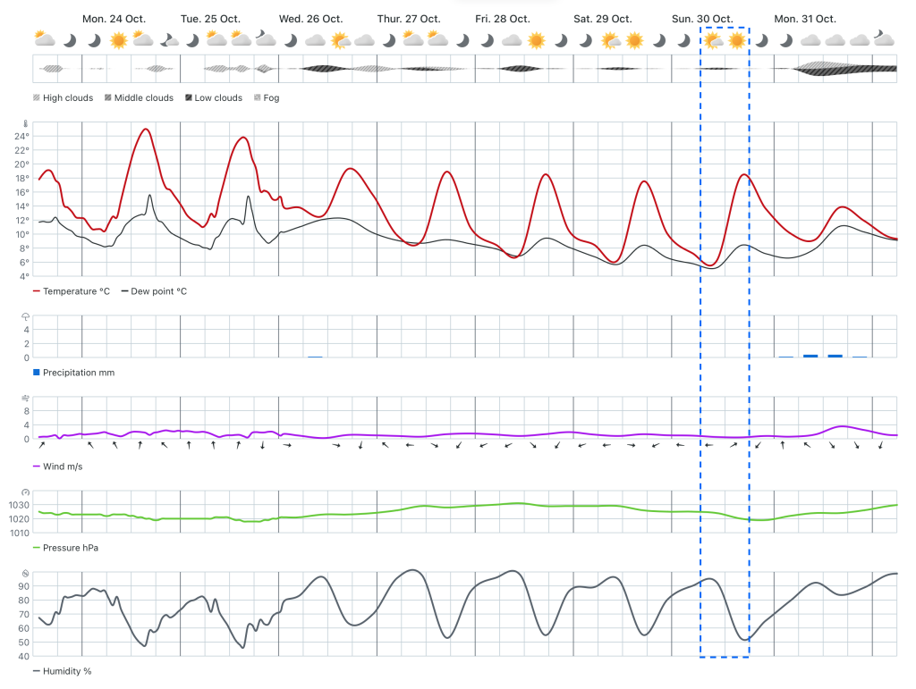
Weather forecast applications like Windy, MeteoBlue, or Yr.No can help with forecasting easily. Let me show the example from the Yr.no site

If we take a look at the Meteogram above, we can see that on Sunday 30. Oct. there will be:
- Humidity: Above 90%
- Pressure: Above 1000 hPA
- Participation: 0mm (No rain)
- Temperature: Temperature and dew point touches at 6℃
- Clouds: Low clouds of 26% coverage
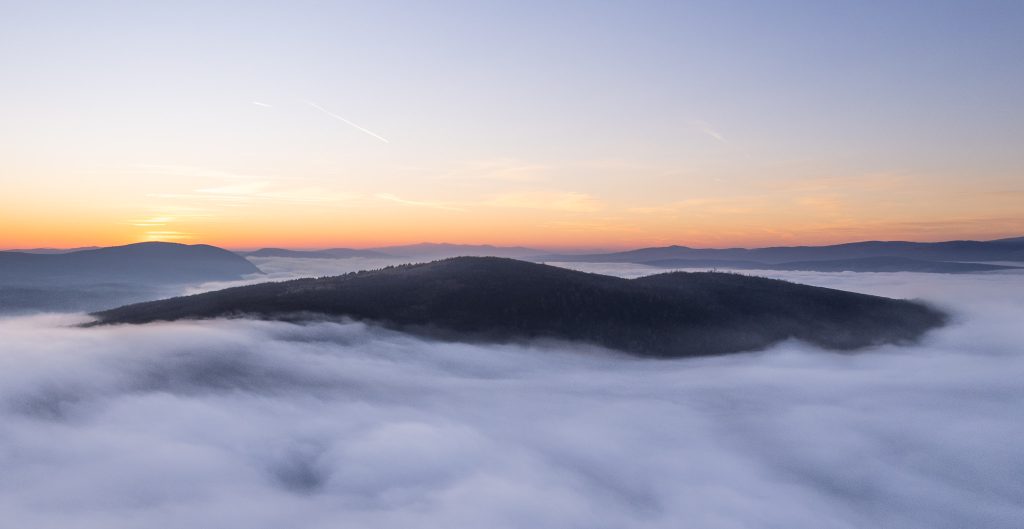
In moments like this fog can show up in the valley, around the sunrise but since this is the forecast we can’t tell with 100% that it will show up. But don’t worry, there is one small trick that might help too. If we take a look at the Air Meteogram of the MeteoBlue forecast company for the same location, we can see the precise height of the clouds, which tells us that some clouds will be available between 500m and 1000m. This information can help when we plan to hike above 1000m in order to see these low clouds below us or be in some woodland around that height where clouds will pass and take some moody woodland photos.

Ending words
Weather forecasts can often change overnight, so check your weather data before you leave and have a backup location in mind. Notwithstanding, the weather forecasts can also be wrong altogether, so if you don’t get foggy moments, enjoy your time outdoors and simply try again another time.

